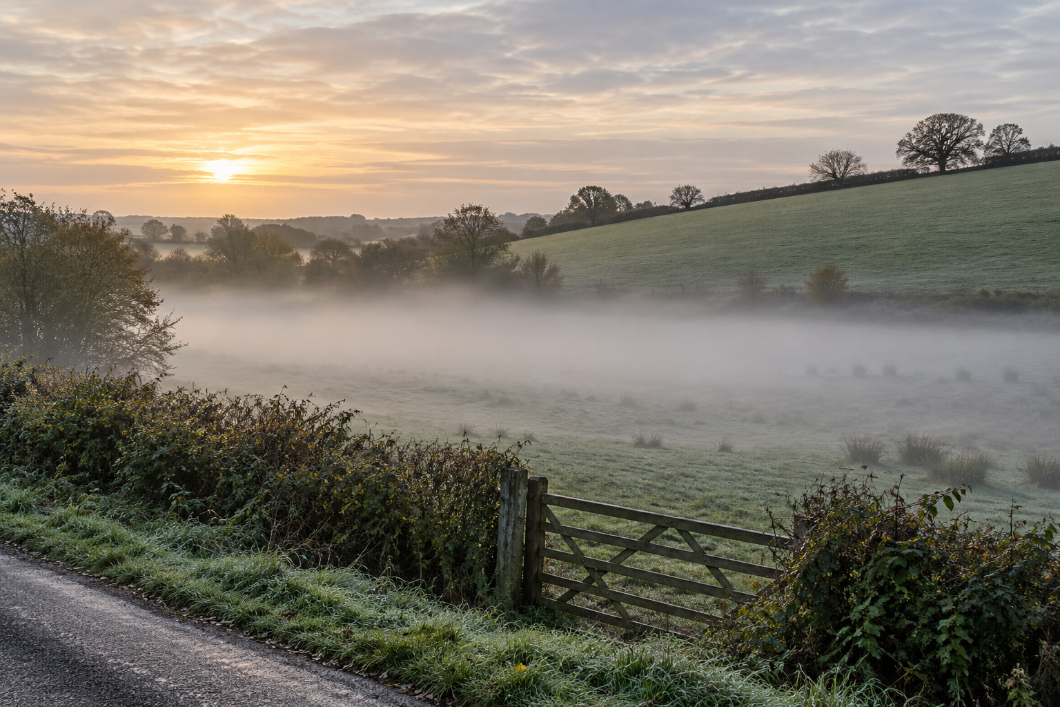
From the lane above a field, the difference can look almost drawn. The higher ground is clear enough to show a hedgerow, while a pale layer hides the gate and the lowest run of grass. It is easy to say that fog has “settled” there. That describes the view, but it skips the more interesting question: what changed in the air over that patch of ground?
The low field is a small weather system inside a larger one. Its hollow can collect air that has cooled on the surrounding slopes. It may be sheltered from wind and lie beside damp soil or a stream. Under the right night sky, these conditions bring the air close to the point where its water vapour becomes suspended droplets. A rise of only a little way up the slope can cross back into clear air. Height matters because it changes temperature, moisture and mixing together, not because fog has a special attraction to the bottom of a field.
The ground cools first
After sunset, the ground continues to give off longwave radiation. On a clear night it can lose heat efficiently, and the thin layer of air touching it cools in turn. The cooling raises that air's relative humidity. When the air reaches saturation, some vapour can condense onto tiny particles and become the droplets that make fog visible. The National Cooperative Highway Research Program's original Highway Fog report explains the cooling, moistening and droplet-growth paths separately. Its definition of fog concerns a cloud at ground level that cuts visibility below one kilometre; a thin veil that still allows a longer view is called mist in formal weather reports. Everyday speech usually grants “fog” a wider territory.
The phrase reaches the dew point is useful, but it does not say where the condensed water will end up. Droplets may form on the blades of grass as dew, or remain suspended in the air as fog. Those outcomes respond to how heat and moisture move in the lowest metres. A wet field after rain may offer more vapour than a dry one, but wetness alone is not enough. Without enough nighttime cooling, the air can remain clear; with a vigorous breeze, the moist near-surface layer may be mixed away before a visible cloud grows.
Why the hollow is colder
Air cooled on a slope becomes denser than nearby warmer air and can drift downhill. In a dip, it adds to the cool air already being made by the ground there. A layer of warmer air above may then sit over the colder air below: a temperature inversion, the reverse of the usual tendency for air to cool with height. The hollow also reduces the reach of the broader wind. These are reasons a low field can cross the saturation threshold before the bank above it does.
The proportions vary from place to place and through the night. In an original study of small valleys at the western edge of Japan's Kanto Plain, Shohei Konno measured temperature, humidity, wind and radiation over several winters. On clear, calm nights, the valley bottoms could be one to two degrees Celsius colder than nearby flat ground. Downslope air contributed to cooling early in the evening. As the inversion strengthened, that drainage weakened, while radiative cooling in the valley continued. The measurements do not supply a universal timetable for every field. They show that “cold air flows down” is only the opening movement of some nights.
Even a slight hollow can make a sharp edge. Mahrt, Pfister and Thomas's station network across a shallow valley recorded temporary cold pools, local drainage flows and narrow boundaries between warmer and colder air. Changes in wind speed could bring mixing and warmth, then a quieter spell could allow cooling again. Their particular valley was measured in far more detail than an ordinary field. It nevertheless explains how one stretch of grass can turn white with fog while a neighbouring rise remains visible, and why the boundary need not stay still.
The moisture need not come from a mysterious “fog bank” waiting nearby. The field, a ditch, damp vegetation or the air already present may supply it. In observations of valley fog near Elmira, New York, reported in the 1970 Highway Fog study, downslope air reached a valley where the near-ground air was already close to saturation. The researchers argued that cooling and mixing helped produce droplets there, while explicitly allowing that other mechanisms could contribute. That is a more useful picture than fog as water vapour simply falling from above: water vapour is invisible, and the visible layer appears when local air conditions permit droplets to grow.
The wind decides what remains aloft
Calm is often listed as an ingredient for radiation fog. The useful condition is more exact: turbulence must be weak enough to let near-ground air cool, while the balance of moisture transport and deposition must still favour droplets in the air. J. D. Price's 2019 observations at six English field sites found that stable radiation fog formed only when the measured variance of near-ground vertical air motion became very small. With more vertical motion, the surface could approach saturation without producing fog, as moisture was transported toward the ground as dew. Once fog had formed, renewed turbulence could dissipate it. These were measured thresholds for those sites and nights, not a wind-speed rule that can be read from a kitchen window.
Fog also changes the cooling process that made it. A forming layer intercepts some outgoing radiation, and its top can cool. What begins as a shallow film near the ground may thicken, while droplets settle or evaporate and the air within the layer moves. An observational campaign in Budapest in 2020–21 followed one long radiation-fog event from surface onset through its later evolution. Increased turbulence accompanied its dispersal. The result is a reminder that fog is an active cloud, not a fixed deposit in the hollow.
Morning light often starts to warm the field and mix the lowest air with the air above. Droplets evaporate as the layer loses saturation, and the hedgerow returns to view. That sequence can be delayed where a low field stays shaded. Measurements in a forested Oregon basin found that local shading by valley walls helped cold pools persist into the day. The study tracked temperature inversions, not a promise that every shaded field will remain foggy. A cloud cover change, fresh wind or a different air mass may also end the veil without a bright sunrise.
Nor does every pale patch over low ground have this nocturnal history. Moist air travelling over a colder surface can form advection fog; evaporation from warmer water into cold air can make another kind. The Highway Fog researchers set out several such routes. Without observations of wind, temperature and moisture, the view from the lane cannot establish which route produced one particular morning. It can still tell us where the threshold was crossed. The field is visible again above the white layer because the air there has a different recent history, even when it belongs to the same landscape.
The gate reappears when that difference closes. Until then, the edge of the fog marks a narrow boundary between air that can keep water invisible and air in which droplets have begun to show it. The low field makes the boundary legible.
A thought worth keeping?